Harney Peak Hike
July 7, 2001
Harney Peak, SD - Highest Point in SD - Near Custer, SD
July 7, 2001
(If you have trouble viewing this page, resize your
window. This will reshuffle pictures and should straighten it
out)
View Log - Log of all contacts made
View QSLS - All QSLs received from the trip
I was pretty enthused when the ARS (Adventure Radio Society) changed the
'Top of the World' event to be an effort
to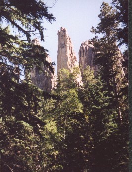 activate
the highest points in all 50 states. I right away decided my goal for the
summer should be to activate Harney Peak, highest point in SD, and Mt Elbert,
highest point in Colorado. Last week my xyl asked if I was up for making
a trip from our QTH in Conifer, CO to the in-laws place in Hot Springs, SD.
It's about a six-hour trip AND it was the in-laws (just kidding GB), so I
hesitated a bit. She mentioned her goals for me for the summer, all of them
having to do with me outside sweating in the sun with yard implements in
my hand. "If there's a day in there for hiking in the hills, I'm up for it".
And so it began. Keith (WUØH) and I (NØSXX) ended up hiking
Harney Peak on July 7, 2001.
activate
the highest points in all 50 states. I right away decided my goal for the
summer should be to activate Harney Peak, highest point in SD, and Mt Elbert,
highest point in Colorado. Last week my xyl asked if I was up for making
a trip from our QTH in Conifer, CO to the in-laws place in Hot Springs, SD.
It's about a six-hour trip AND it was the in-laws (just kidding GB), so I
hesitated a bit. She mentioned her goals for me for the summer, all of them
having to do with me outside sweating in the sun with yard implements in
my hand. "If there's a day in there for hiking in the hills, I'm up for it".
And so it began. Keith (WUØH) and I (NØSXX) ended up hiking
Harney Peak on July 7, 2001.
I called Keith right away to see if he was available Saturday for a hike
to Harney. Short answer, available but, "Man... that's a long hike". He was
easy to talk into it and a
little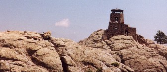 research
produced the 'Cathedral Spires' trail that reached the peak in only 2.5 miles
with an elevation gain of a couple thousand feet, to reach the summit of
7242 feet. Not a bad hike even for a couple of out of shape guys.
research
produced the 'Cathedral Spires' trail that reached the peak in only 2.5 miles
with an elevation gain of a couple thousand feet, to reach the summit of
7242 feet. Not a bad hike even for a couple of out of shape guys.
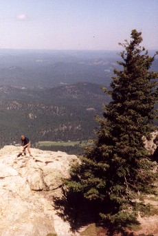
We left Hot Springs at 8:00 AM, drove through Custer, SD to Sylvan Lake and
then a little beyond to the trailhead (would have been less beyond but missing
a turn or two, I extended the drive a bit). Defying all odds we hit trail
at about 9:15, a
few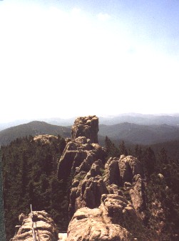 minutes ahead of
schedule. Just a few minutes into the hike we passed the trail namesakes,
the cathedral spires. We reached the summit at about 11:00. During our stay
at the summit, we usually had the company of about a dozen people. The views
were magnificent. At the summit of Harney sits the fire lookout tower. This
was built in the 1940's and manned during the summer, I believe,
as
minutes ahead of
schedule. Just a few minutes into the hike we passed the trail namesakes,
the cathedral spires. We reached the summit at about 11:00. During our stay
at the summit, we usually had the company of about a dozen people. The views
were magnificent. At the summit of Harney sits the fire lookout tower. This
was built in the 1940's and manned during the summer, I believe,
as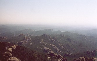 late as the 1980's.
Keith began setting up his station: a sw30+, paddlette key and homebrew 30
meter inverted vee dipole. There were only a few trees at the summit and
most of those small. He picked one of the larger and had the dipole in place
and was on the air shortly after 11:30.
I hiked another 40 yards away, trying to separate us a little so that we
would have as little mutual interference as
possible.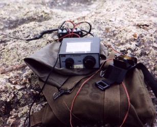
 My gear consists of a K2, a bulldog paddle
and hustler vertical that I've put together specifically for this 'mountain
topping' kind of activity. It has a 3/4" PVC mast that is drilled so that
I can insert pieces of 3/8" threaded rod in the bottom to form a tripod.
A 6' piece of 1/2" copper pipe slides partway into the PVC mast, leaving
the base of the copper about 3' above ground. The copper pipe is made to
accept a hustler vertical resonator and I attach 3 resonant radials using
alligator clips. This allows me to set up an antenna without the need for
any external supports.... pretty important when you're up above tree line!
When disassembled all the pieces slide into the PVC mast leaving me with
something that resembles a walking stick. I had the gear set up and was on
the air and put the first qso in the log
at
My gear consists of a K2, a bulldog paddle
and hustler vertical that I've put together specifically for this 'mountain
topping' kind of activity. It has a 3/4" PVC mast that is drilled so that
I can insert pieces of 3/8" threaded rod in the bottom to form a tripod.
A 6' piece of 1/2" copper pipe slides partway into the PVC mast, leaving
the base of the copper about 3' above ground. The copper pipe is made to
accept a hustler vertical resonator and I attach 3 resonant radials using
alligator clips. This allows me to set up an antenna without the need for
any external supports.... pretty important when you're up above tree line!
When disassembled all the pieces slide into the PVC mast leaving me with
something that resembles a walking stick. I had the gear set up and was on
the air and put the first qso in the log
at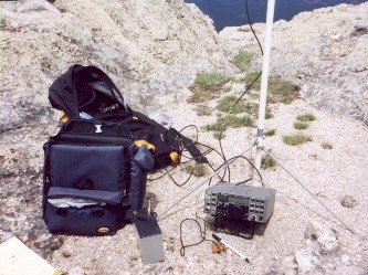 11:20. After
that first qso, I looked around and thought 'This is great! Good condx and
not a cloud in the sky!'. After making a few QSOs I took a break and went
back to check on Keith. He'd put one
QSO
11:20. After
that first qso, I looked around and thought 'This is great! Good condx and
not a cloud in the sky!'. After making a few QSOs I took a break and went
back to check on Keith. He'd put one
QSO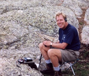 in the
log on 30 meters and was also having a fine time. I went back to my rig and
flipped it on.... nothing but static! Time to cry the blues. I'd hardly
noticed but the clouds were right on top of us! As I tuned around a little,
I got shocked several times as I touched the rig. I can't quite explain THAT
phenomenon (if you can feel free to send me an email) but it didn't feel
like a great time to be operating. I shut down and lay the antenna down.
I consulted with Keith and we decided to stick it out for a while. Sure enough,
30 minutes later the clouds were gone and we were back on the air. Over the
next few minutes, I added several more QSOs to the log. I had announced on
the ARS wilderness alert
and
in the
log on 30 meters and was also having a fine time. I went back to my rig and
flipped it on.... nothing but static! Time to cry the blues. I'd hardly
noticed but the clouds were right on top of us! As I tuned around a little,
I got shocked several times as I touched the rig. I can't quite explain THAT
phenomenon (if you can feel free to send me an email) but it didn't feel
like a great time to be operating. I shut down and lay the antenna down.
I consulted with Keith and we decided to stick it out for a while. Sure enough,
30 minutes later the clouds were gone and we were back on the air. Over the
next few minutes, I added several more QSOs to the log. I had announced on
the ARS wilderness alert
and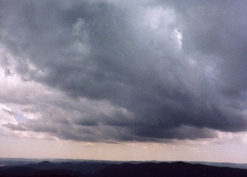 on
the
on
the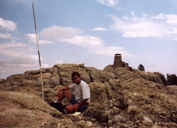 QRPL email
list that we would be on the air. It was GREAT fun talking to a bunch of
guys that had seen those announcements and were listening for us. It was
also fun hearing from K6III who I had also talked to from the top of Mt Sherman,
one of the Colorado 14ers, about a year before. Soon the clouds were back
and more static. I kept operating but soon I was getting shocked again! When
it started raining, we decided that was it and started packing up. The sprinkle
of rain quit as we finished packing up so the hike back was enjoyable. When
I returned to Hot Springs, my wife and mother-in-law were surprised it had
gone so well. They had been hearing reports of golf ball size hail in the
area we were hiking! THIS
hadn't
QRPL email
list that we would be on the air. It was GREAT fun talking to a bunch of
guys that had seen those announcements and were listening for us. It was
also fun hearing from K6III who I had also talked to from the top of Mt Sherman,
one of the Colorado 14ers, about a year before. Soon the clouds were back
and more static. I kept operating but soon I was getting shocked again! When
it started raining, we decided that was it and started packing up. The sprinkle
of rain quit as we finished packing up so the hike back was enjoyable. When
I returned to Hot Springs, my wife and mother-in-law were surprised it had
gone so well. They had been hearing reports of golf ball size hail in the
area we were hiking! THIS
hadn't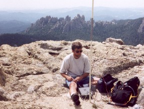 surprised
them as Keith and I have a long history of attracting rain, snow and generally
crummy wx whenever we camp/hike. It seemed that for once we had defied the
murphy hiking gods and had missed the big storm.
surprised
them as Keith and I have a long history of attracting rain, snow and generally
crummy wx whenever we camp/hike. It seemed that for once we had defied the
murphy hiking gods and had missed the big storm.
We ended up making 11 QSOs on 20 and 30 meters.
Here are copies of the log. I ended up
with 10 QSOs. Condx on
30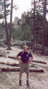 meters
turned out to be pretty crummy and that first QSO was the last that Keith
made. Whenever I do a portable operation I figure that I've been successful
as soon as I put one QSO in the log. I've got to figure that those 11 QSOs
was a HUGE success. We had a great time and I look forward to that next mountain
topper to Mt Elbert in Colorado!
meters
turned out to be pretty crummy and that first QSO was the last that Keith
made. Whenever I do a portable operation I figure that I've been successful
as soon as I put one QSO in the log. I've got to figure that those 11 QSOs
was a HUGE success. We had a great time and I look forward to that next mountain
topper to Mt Elbert in Colorado!